April 2002
A Comparison of Directed Crop Scouting
and Traditional Sampling
Key words: remote sensing, directed
sampling, spatial statistics
Update on Directed Crop Scouting: Issue
2 of 2
G.K. Blumhoff
Choosing different sampling methods and
mapping algorithms can be can be a challenging task. The basic goal is to
derive an informative map of field conditions without having to scour every inch
of the field. A directed approach to crop scouting can provide valuable
information about the field without intense sampling requirements. This method
lets the field do the talking. However, depending on the method, bias can
result, producing a skewed view of actual field conditions. Thus, psuedo-random
approaches have been advocated to remove this problem. This type of sampling
may also produce errors due to sparse sample numbers and distorted maps not
representative of actual field conditions. This article summarizes a research
project which evaluated both types of sampling in order to decide which method
is more useful when applied to site-specific requirements.
Factors such as efficiency and quality
of information obtained from traditional crop scouting methods and the proposed
directed method were compared in this study. Specifically, tradeoffs exist
between increases in the density of sampling, labor and the expense to collect
and analyze samples, and the resulting accuracy of maps to represent the spatial
patterns in crop conditions observed.
Existing methods address identification and control thresholds, but do
not specifically address the "How to?" aspects of crop scouting
related the "location of" and/or "extent of" yield
influencing factors occurring in the field.
The March newsletter provided a summary on an
alternative method of crop scouting tailored to precision agriculture
applications. Directed sampling involves the use of remotely sensed image data
to guide or target sampling. Research efforts were centered on testing the
feasibility of existing sampling methods (psuedo-random or zigzag sampling) and
targeted sampling with the use of secondary information such as yield maps,
soil types, and/or remote sensing. Remote sensing offers the potential for
identifying small-scale spatial patterns in crop conditions, crop yield
patterns across the field, and optimizing crop scouting methods to quantify
those problem areas.
The crop scouting method comparison was located on
about 250 acres of corn and soybeans located on two local growers farms in west
central Indiana. The procedure described in the March newsletter was used to
direct sampling within the corn and soybean fields. Traditional sampling or
zigzag sampling was also performed within these fields to provide to separate
data sets to compare. Variability maps were produced from the sample results
and compared to a map produced from pooled (intensive, directed, and zigzag data).
Map production was driven by sample density, data relationships, and map
quality that could be achieved. Three different map production algorithms were
used to produce maps. They included ordinary kriging (spatial statistics),
normal matching (basic statistics), and inverse distance weighting (common
default). Although complicated and somewhat subjective in nature, ordinary
kriging was selected because it has the ability to produce informative results
given sparse data. Normal matching is an older method that involved data
transformation. Basically, it requires that there be a significant relationship
between remote sensing data and data collected by crop scouts on the ground.
This method produces a spatially continuous map of individual pest variability
based on sparse ground collected data and dense remote sensing data. Lastly,
inverse distance weighting was incorporated as a contingency in cases when the
other methods guidelines could not be satisfied.
Example maps are provided to express the differences
between directed, zigzag (psuedo-random), and intensive datasets. Figure 1 and
Figure 2 show examples of map results obtained for each of the crop scouting
methods. The maps are presented with directed sampling results on the left,
pooled data in the middle, and traditional zigzag sampling results on the
right. The main variations between the methods are in the detail of ground
sampled data. An important detail to observe is related to spatial detail and
the ability to categorize the data for future management applications. Also, it
is important to recognize the quality of the estimates produced regarding true
variability and artificial results.
Figure 1 shows plant height in a 120-acre cornfield
collected in mid-August. The number of samples collected for each method
included: 54 samples for zigzag, 51 samples for directed, and a total of 105
samples to pool for comparison. In this case, sample data observed by both
methods were added together to produce a higher density dataset to compare the
two sampling methods. An aerial sensor acquired the remotely sensed data on
August 14, 2000 at 11/2 meter spatial resolution. The relationship
between plant height and the image data maintained a high R2 value
of .65. This relationship met the normal matching requirements of >
.35 R2.The results verify the limitations of the traditional or
zigzag crop scouting method. Only a small portion of field variability was
identified with zigzag estimates when compared to interpolated map results
shown in the pooled data. Also, class boundaries appear somewhat artificial,
including a lack of detail in areas of the field where the shortest plants were
located. This displays the limitations of the method regarding the
identification of the area and extent of potentially important crop limiting
factors occurring in the field.
Figure 2 shows map surfaces of estimated yield from
ground collected data for a 65-acre soybean field in mid-August. The number of
samples collected for each method included: 16 samples for zigzag, 18 samples
for directed, and a total of 71 samples to pool for comparison. Note that the
pooled dataset contains a larger sample number. For research purposes, data
were collected at additional sample locations to provide greater detail in map
results. In some cases, data sparsity prevented the use of spatial analysis,
thus requiring greater sample numbers. An aerial sensor acquired the remotely
sensed data on August 14, 2000 at 11/2 meter spatial resolution. The
relationship between estimated hand-yield and the image data maintained a high
R2 value of .51, which satisfied the normal matching requirements.
Similar to results displayed in Figure 1, the map produced from zigzag data
shows artificial "bulls-eye" patterns with a large amount of
smoothing. Further, it also shows problems that the method has related to
over/under-estimation of yield variability.
The directed or targeted sampling method has the
potential to improve site-specific pest management strategies. Further, this
method could also impact agriculture related to other crop production
parameters and promote improved environmental quality.
Zigzag: Ordinary Kriging
![]()
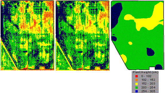
Figure 1. Map surfaces (raster data) produced from
plant height sample data collected August 14, 2000.
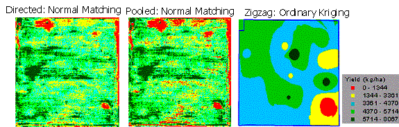
Figure 2. Map surfaces of SB1 field produced from
estimated hand-yield data. SB1 field produced sample data collected August 1-5,
2000. Areas with a low reading are those exhibiting a stress or deficiency.
For more information:
Blumhoff, Greg K., 2002. Spatial
Variability Assessment With Remote Sensing and Directed Sampling. M.S. thesis.
Purdue University, West Lafayette, IN.