May 2002
Comparison of Organic Matter Interpolated Maps From 0.5 and 2.5 Acre
Grids Using Geostatistics
Keywords: Spatial Analysis,
Estimation Algorithms, Mapping, Samplinge Density
Ignacio
Colonna (iacolonn@uiuc.edu)
Introduction
The practice of spatially intensive soil sampling has increased in the
past few years among farmers mainly due to the accompanying increase in
site-specific services offered by agriculture dealers (e.g. variable rate
application of lime, fertilizers, or pesticides). Typical sampling densities
are 1 sample per 2.5 to 4 acres. This data is then usually interpolated using
simple algorithms such as Inverse Distance Weighting (IDW) or Moving Averages
contained in standard GIS software packages. Simple algorithms are easy to use
and computationally fast, but at sparse sampling densities may yield attribute
maps with substantial errors. These errors are rarely checked by final
end-users. Possible advantages of more accurate (and somewhat more complicated)
methods are thus not realized. This newsletter summarizes the results from a
comparison of four interpolation algorithms. A somewhat didactic and graphical summary of this information is
available at a poster. The full
version of the original MS thesis can be downloaded here.
Research Objective and
Hypotheses
The objective was to compare the performance of different interpolation
methods with and without the use of secondary information at a relatively
intense (1 sample/0.5 ac) and sparse (1 sample/2.5 ac) sampling density. The
hypotheses are:
1.
Interpolation methods that incorporate information of spatial correlation of
the data and make use of secondary variables may have substantially less error
than those that do not.
2. The
relative advantage in the use of these methods over the simple ones is
inversely related to the sampling density.
Methods
The study used Soil Organic Matter (SOM) half acre grid data from a 120
acre field on the Purdue Davis Agricultural Center (DPAC), which is located
near Farmland in east, central Indiana. SOM was mapped with alternative
algorithms using the half acre data and with simulated 2.5 acre data. The 2.5
acre data was simulated by taking one of every five of the original samples in
a pattern that would be similar to that used when doing 2.5 acre grid
sampling. This generated five different
sets of 2.5-acre SOM data, all of which were used in subsequent testing of the
estimation techniques.
The four interpolation methods analyzed are: inverse distance weighting
(IDW), ordinary kriging (OK), simple kriging with varying means (SKVM), and
co-kriging. IDW is used with powers of two and four. Kriging is an interpolation
algorithm that assumes a continuous increase in variability with distance. The spatial
variability is quantitatively described by what is called a “semivariogram” and
its corresponding model. The interpolation weights for the available samples are
then estimated based on the chosen semivariogram model.
Co-kriging and SKVM are ways of incorporating information from other
correlated variables to improve the kriged estimates. Usually, co-kriging and
SKVM use data that is cheap and easy to collect to improve the estimates for
variables for which data collection is expensive and/or difficult. This study
uses a remotely sensed bare soil image as the alternative data set for
co-kriging and SKVM.
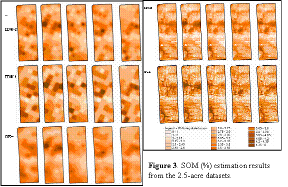
Results
Both methods based on the use of secondary information showed a markedly
better estimation performance at the two sample densities used (figure 1).
Moreover, the five alternative 2.5-acre datasets yielded considerably
inconsistent estimation results for all methods based only on SOM data, while
SKVM and Cokriging showed an acceptable level of consistency among these
datasets (figures 2 and 3)
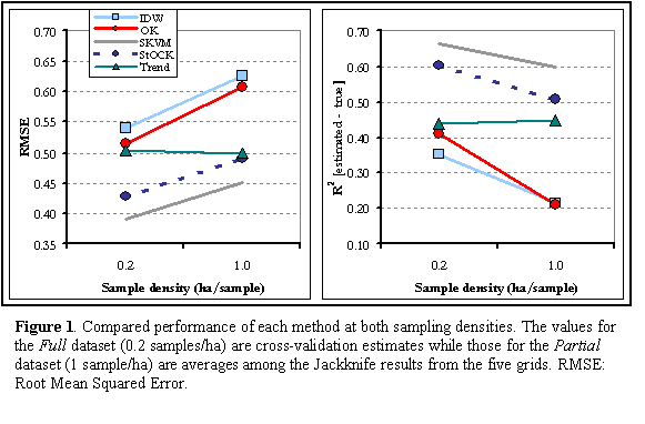
Conclusions:
For this dataset, SKVM was shown to be the best method for both sampling
densities tested. Even at the high 0.5- acre sampling density, the methods that
make use of secondary information showed considerably better results than IDW
or OK. At the 2.5 acre sampling density, IDW and OK yielded poor and
inconsistent results. Furthermore, SKVM is significantly less complicated than
cokriging in its computations and in the requirements to be satisfied by the
data, thus appearing more easily applicable among final users without a deep
understanding of geostatistics. According
to these results, the common use of simple interpolation techniques at the most
widespread sample densities of about 1sample/2.5 acres should be seriously
revisited by final users. The use of other potential sources of secondary
information like soil electrical conductivity or topography might be explored
as alternatives to bare soil imagery for spatial estimation of other variables
of agronomic relevance.
For More
Information:
Ignacio Colonna, Kenton Ross and Robert
Nielsen, “Comparison of Organic Matter Interpolated Maps From 0.5 and 2.5 Acre
Grids Using Geostatistics”, poster presented at 2001 ASA meetings, Charlotte,
NC.
Available at: http://icdweb.cc.purdue.edu/~colonna/ASA_OM3b.pdf
Ignacio Colonna, “Accuracy of Spatial Estimation Methods for
Site-Specific Agriculture at Different Sample Densities” Department of
Agronomy, Purdue University, West Lafayette, IN, 2001. Pdf available at: http://icdweb.cc.purdue.edu/~colonna/index2.html